Navigation in indoor and underground environments has been extensively studied to realize the automation of the home, hospital, office, factory, and mining services, and various techniques have been proposed for its implementation.
Scientists at the University of Tokyo have come up with a new technology to navigate in places where GPS can’t reach. Using their technology, they could calculate the receiver’s position in the basement of a six-story building.
Interestingly, the technology uses muon-detecting ground stations synchronized with an underground muon-detecting receiver.
Muons have recently gained attention for their capacity to enable us to peer through pyramids, explore deep beneath volcanoesand observe cyclones. Muons fall continuously and regularly (10,000 per square meter per minute on average) and cannot be manipulated.

Professor Hiroyuki Tanaka from Muographix at the University of Tokyo said,“Cosmic-ray muons fall equally across the Earth and always travel at the same speed regardless of what matter they traverse, penetrating even kilometers of rock. Now, by using muons, we have developed a new kind of GPSwhich we have called the geometric positioning system (MIPS), which works underground, indoors, and underwater.”
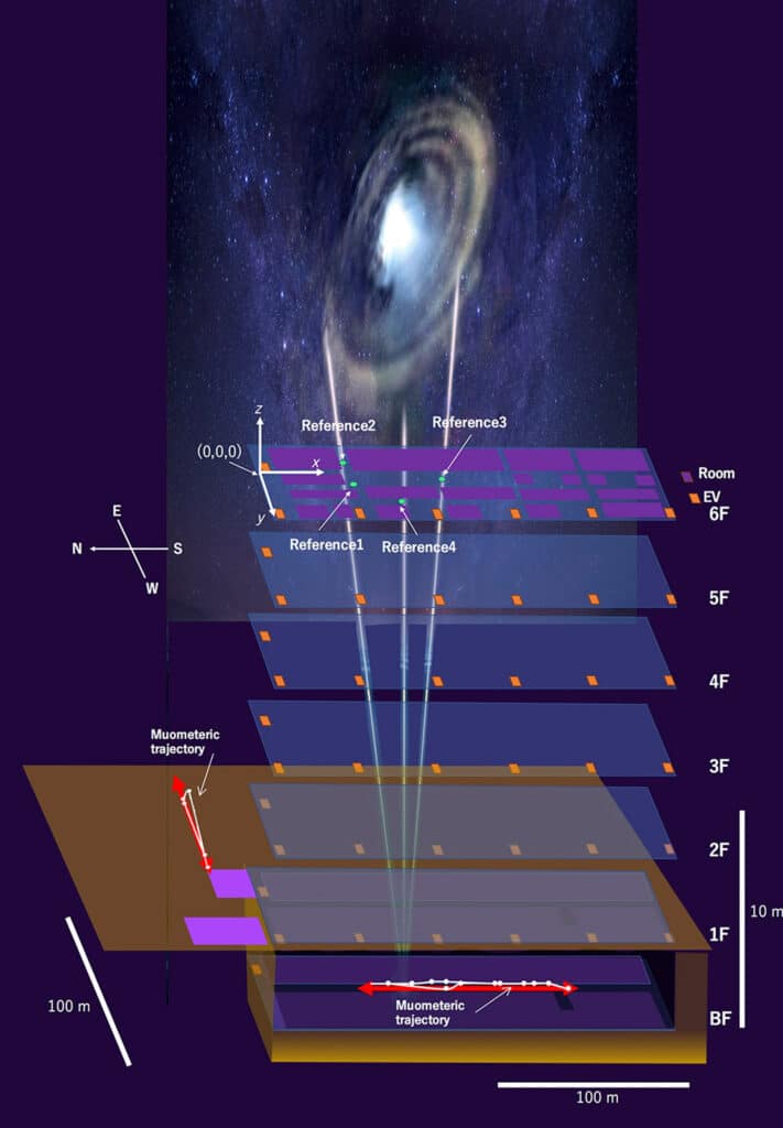
Created to detect seafloor changes, MuPS uses four muon-detecting reference stations aboveground to provide coordinates for a muon-detecting receiver underground. The receiver had to be wired to a ground station in earlier iterations of this technology, severely limiting movement. However, the most recent study synchronizes the ground stations with the receiver using high-precision quartz clocks.
The receiver’s coordinates can be calculated using the four parameters supplied by the reference stations and the synchronized clocks required to gauge the muons’ “time-of-flight.” This new system is called the muometric wireless navigation system (MuWNS).
For testing, scientists placed the detectors on the sixth floor of a building while a “navigate” took a receiver detector to the basement floor. They held the receiver and moved carefully through the basement’s hallways. Instead of using real-time navigation, measurements were obtained to determine their course and validate the path they had followed.
Tanaka said,“The current accuracy of MuWNS is between 2 meters and 25 meters, with a range of up to 100 meters, depending on the depth and speed of the person walking. This is as good as, if not better, single-point GPS positioning aboveground in urban areas. But it is still far from a practical level. People need one-meter accuracy, and the key to this is time synchronization.”
“Improving this system to enable real-time, meter-accurate navigation hinges on time and money. Ideally, the team wants to use chip-scale atomic clocks (CSAC): CSACs are already commercially available and better than the current quartz clocks. However, they are too expensive for us to use now. But, they will become much cheaper as the global demand for CSAC for cellphones increases.
In the future, MuWNS might be utilized to steer driverless vehicles underground or to direct underwater robots. Apart from the atomic clock, all the other electronic parts of MuWNS can now be miniaturized, and the team anticipates that it will soon be possible to integrate MuWNS into hand-held devices, such as your phone. This could transform the way search, and rescue teams operate in emergency situations like a building or mine collapse.
Journal Reference:
- Hiroyuki K. M. Tanaka, Giuseppe Gallo, Jon Gluyas, Osamu Kamoshida, Domenico Lo Presti, Takashi Shimizu, Sara Steigerwald, Koji Takano, Yucheng Yang, Yusuke Yokota, “First navigation with wireless biometric navigation system (MuWNS) in indoor and underground environments,” iScience: June 15, 2023, DOI: 10.1016/j.isci.2023.107000
Note: This article have been indexed to our site. We do not claim legitimacy, ownership or copyright of any of the content above. To see the article at original source Click Here


